danielgraf

joined 2 years ago

Someone would need to get that data out of the app. Either as GPX or some other format. I do not think these devices are able to send the position to some configurable endpoint. A quick search for nut tracker and home assistant does not yield any reasonable results.

I think we are out of luck at that point. But maybe someone knows about a more open tracker device which could be configured.

[–] danielgraf@discuss.tchncs.de 4 points 3 days ago (1 children)

Reitti displays data coming either from an import. You could upload GPX, GeoJson files or export the data from google maps and import that. If you want more up to date data, you could install an app on your phone which pushes your latest locations into Reitti. GPSLogger or Owntracks are at the moment supported for that

No, not really. It just makes it easier to spin up all the needed services and it is at the moment the "documented" way.

On the release there is also jar of Reitti.

If you need any help in starting that, let me know.

[–] danielgraf@discuss.tchncs.de 20 points 4 days ago

You are right, I missed that they are still open for the other services. I have mine running behind traeffik and did removed all port definitions.

I will change the compose file to only expose Reitti.

Thanks for the feedback🙏


After an intensive week of development, I'm proud to present Reitti v1.1.0 with a big list of improvements!

✨ What's New in This Update:
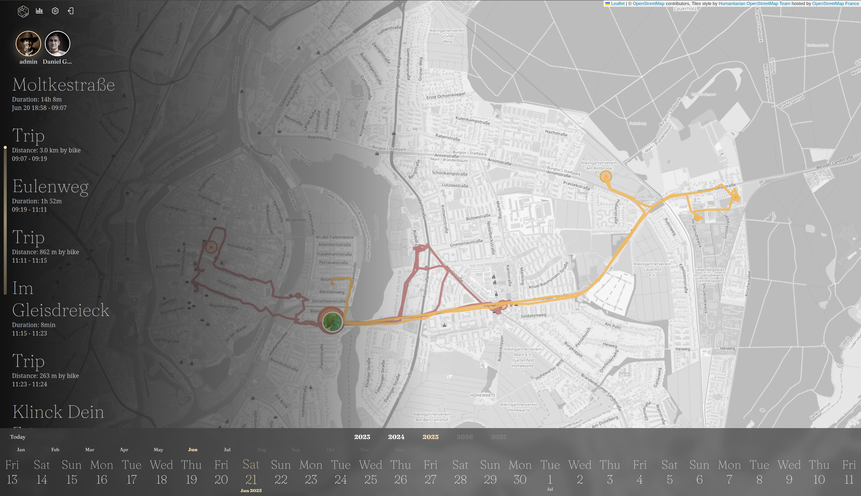
Family & Friends Tracking: Now see multiple users on the same map - perfect for keeping tabs on your whole family or group adventures!
Faster Processing: Experience significantly faster data crunching after importing new location data
Redesigned Settings: Completely overhauled UI makes customization simpler and more intuitive
Imperial Unit Support: Added miles and feet for our friends in the US and elsewhere
Enhanced Maps: New color mode to personalize your viewing experience
Google Timeline Import 2.0: Now supports legacy formats plus both iOS and Android variants
OwnTracks Integration: Direct connection to your existing OwnTracks Recorder
Docker Optimization: New arm64 images for efficient deployment

🔍 New to Reitti?
Reitti is your ultimate privacy-focused location companion that:
📍 Builds smart maps of your travels
📊 Uncovers your movement patterns
🔐 Keeps all data securely on YOUR device
💙 Stays 100% free and open-source

🚦 Ready to Upgrade?
📲 Get the Latest Version
Support Development on Ko-fi

Huge thanks to this amazing community for your suggestions and feedback!

If you are running Reitti with Docker, you can set the environment variable DANGEROUS_LIFE to true. This will enable a new section in the Settings. There, you can use the button 'Clear and Reprocess'. This will delete all visits and trips and set all raw data points to unprocessed. During the next run, everything will be recalculated. In that settings section, you could also press the 'Start Processing' button if you don't want to wait. Make sure to wait until the success message appears. It can take a while until all data is deleted and switched to unprocessed.

[–] danielgraf@discuss.tchncs.de 4 points 1 week ago (2 children)

Greetings, @Pandoras_Can_Opener@mander.xyz, that sounds like a truly wonderful idea, and as a fellow cat owner, it brings me great joy to hear about it. 😻

In fact, I have recently changed the analysis of data, which is now performed in near real-time as soon as new data becomes available. I am currently working on the functionality to display multiple users (or, in your case, Pandora) on the map, which should be beneficial to your idea.

Now, the primary question is, how can we integrate the data from the tracker into Reitti. Thats something I have no idea at the moment. Do you have any Infos about that?

Hi ada,

yes, this will impact the visit calculation. Visits are calculated in building clusters of at least 5 points in a range of 100m over a duration of at least 5 minutes. If there is only one point logged for example at work or home, Reitti is not able to detect when you left it because every point is just an instant in time and does not carry any duration information with it.

The more points we have to calculate Visits the more accurate it will be. I personally have set up GPSLogger to log every 30 seconds no matter how far I travelled but with at least 40m of accuracy.

Hi LazyToad,

it depends. Reitti on its own does not import any pictures. It only shows fetches them from Immich. For that to work it needs the geolocation where the image was taken in the exif data. You need to check if your expected image has this data in Immich. If it is available it shoud be displayed on the map if you select the day the picture was taken.

Does it show the location in Immich? You can verify this if you open the image in Immich and let it display the Info.

If it is showing, then it still could be that it is a bug in Reitti. Feel free to open an issue then :)

Thank you very much for these kind words. Means a lot to me if my little tool brings value to you :)

[–] danielgraf@discuss.tchncs.de 1 points 1 week ago (1 children)

Cool, thanks for the feedback.

For: 1: There should be something about downloading in the Photon logs. You can check with docker compose logs photon. I do not remember how long it took to download the index for Germany, but it was noticeable. It depends a lot on how you are connected to the internet and then how long it takes to extract the index.

2: You should also see that in the log of Photon. If the default does not work reliably, you can create an account on Geoapify; it is free, and you get 3000 reverse geocode requests per day. I personally have Photon for DE and then the default service and additional Geoapify.

3: Yeah, I was also thinking about that. In the end, a per-user setting and then the overlay should be disabled, but it could take a while until I can get to it.

[–] danielgraf@discuss.tchncs.de 1 points 1 week ago (1 children)

I am glad it worked out for you in importing the first file. I am still puzzled why it took that long.

For the new format, did you have Android or iOS? With the timeline export from Google Maps on iOS, we can not do anything at the moment because there is actually no raw data in it. Only information like you stayed in this timeframe at that point and you traveled between these points. It's actually a little bit funny that it aggregates to the same data Reitti uses in the end.

If you are on Android, it could also be a bug when importing that file. I only had a small one from one of my accounts to test. If you mind creating a bug report, I will have a look. If you do not want to attach the export file there, feel free to send it to daniel@dedicatedcode.com. I will have a look at it then privately. No problem.

For the overlap in exports, it depends. If the points are the same, meaning they have the same timestamp, then Reitti will discard them. If not, they will be handled like every other new data and will end in recalculating visits and trips around that particular time.

Glad I could help :)


Hey everyone!

I'm excited to introduce Reitti, a location tracking and analysis application designed to help you gain insights about your movement patterns and significant places—all while keeping your data private on your own server.

Core Capabilities:

  • Visit Tracking: Automatically recognizes and categorizes the places where you spend time, using customizable detection algorithms
  • Trip Analysis: Analyzes your movements between locations to understand how you travel whether by walking, cycling, or driving
  • Interactive Timeline: Visualizes all your past activities on an interactive timeline with map and list views that show visit duration, transport method, and distance traveled

Photo Integration:

  • Connect your self-hosted Immich photo server to seamlessly display photos taken at specific locations right within Reitti's timeline. The interactive photo viewer lets you browse galleries for each place.

Data Import Options:

  • Multiple Formats Supported: Reitti can import existing location data from GPX, GeoJSON, and Google Takeout (JSON) backups
  • (Near) Real-time Updates: Automatically receive location info via mobile apps like OwnTracks, GPSLogger or our REST API

Customization:

  • Multi-geocoding Services: Configurable options to convert coordinates to human-readable addresses using providers like Nominatim
  • User Profiles: Customize individual display names, password management, and API token security under your own control

Self-hosting:

  • Reitti is designed to be deployed on your own infrastructure using Docker containers. We provide configuration templates to set up linked services like PostgreSQL, RabbitMQ and Redis that keep all your location data private.

Reitti is still early in development but has already developed extensive capabilities. I'd love to hear your feedback and answer any questions to tailor Reitti to meet the community's needs.

Hope this sparks some interest!

Daniel

view more: next ›